City of Norcross: Heritage Park
Service Details
Surveying
Boundary, topographic and as-built surveying performed in preparation of Base Map for design development and construction phases for the improvements to Thrasher, Mauldin and Heritage Parks. SEI obtained right of way plans, deeds, plats ifor project planning and for future boundary resolution. SEI utilized survey grade GPS units to establish survey control for each Park for Vertical (MSL) and horizontal ontrol. Control points were confirmed for accuracy by running a level loop at each Park. A robotic total station was utilized to gather the data required for the Base Map. These include; topography, creeks, streams or ditches, storm water, sanitary sewer pipes and associated structures, curb, gutter, pavement, striping, traffic control devices, all above ground visible utilities, property corners, right of way markers and any unusual features. Information gathered was processed and verified for accuracy, imported into CAD format. Analysis of the boundary lines was performed and resolved. The Base Map was provided to our Landscape/Planning Department to begin conceptual design.
 Civil Engineering
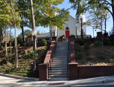
Heritage Park is a small pocket park located between the City Hall and new Community Center on the hill across the street. The park is on an axis with City Hall and provides a shaded seating area for employees of the City to eat lunch. It is also planned to be a spring and summer wedding venue. The design calls for a graded terrace between Lawrenceville Street and the Community Center above. The terrace is surrounded with low walls and beautiful native flowers and plants. The scope includes over 500lf of retaining walls, steps, railings, lighting and site furnishings selections. The project is a major focal point for the city and can be seen from all the winows in City Hall. SEI was selected for the work due to their ability to provide highly detailed landscape plans with attention to seasonal color changes and well planned pedestrain access.

