Cobb County DOT: East West Connector at Fontaine Road
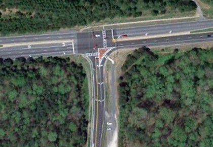
This project included the addition of a northbound free flow right turn lane off Fontaine Road at the intersection with the East West Connector. The purpose of the intersection improvement is to improve the traffic operations and enhance the safety of this intersection. The challenge of the project was to design the free flow lane in spite of topographic difficulties on the south side of the East West Connector and to ensure safe and efficient operation of the traffic signal. The free flow right turn required the relocation of a significant amount of guardrail along the south side of the East West Connector. The existing guardrail was relocated based on the new lane configuration. The installation of the free flow lane also required a Traffic Signal Modification as the mast arm and pedestrian facilities were relocated outside of the improved intersection. This intersection improvement also benefits pedestrians and bicyclists making their way to the Silver Comet Trail along the north side of the East West Connector.
Service Details
 Surveying Route Survey
Route surveying performed in preparation of Base Map for design of intersection improvements for the East-West Connector at Fontaine Road in Cobb County. SEI obtained right of way plans, deeds, plats and other pertinent information for project planning and for future right of way resolution. SEI utilized survey grade GPS units to establish survey control throughout each route for Vertical (MSL) and horizontal control. These control points were confirmed for accuracy by running a level loop on each route. A robotic total station was utilized to gather the data required for the Base Map. These include; topography, creeks, streams or ditches, storm water and sanitary sewer pipes and associated structures, curb, gutter, pavement, striping, traffic control devices, all above ground visible utilities, property corners, right of way markers and any unusual features. Information gathered was then processed and verified for accuracy, imported into CAD format. Analysis of the right of way was performed and resolved. The Base Map was then provided in Microstation format for our Transportation Department to begin conceptual design.
Transportation Engineering
This project included the addition of a northbound free flow right turn lane off Fontaine Road at the intersection with the East West Connector. The purpose of the intersection improvement is to improve the traffic operations and enhance the safety of this intersection. The challenge of the project was to design the free flow lane in spite of topographic difficulties on the south side of the East West Connector and to ensure safe and efficient operation of the traffic signal. The free flow right turn required the relocation of a significant amount of guardrail along the south side of the East West Connector. The existing guardrail was relocated based on the new lane configuration. The installation of the free flow lane also required a Traffic Signal Modification as the mast arm and pedestrian facilities were relocated outside of the improved intersection. This intersection improvement also benefits pedestrians and bicyclists making their way to the Silver Comet Trail along the north side of the East West Connector.
Traffic Engineering
The purpose of the intersection improvement for the East West Connector and Fontaine Rd was to improve the traffic operations and enhance the safety of this intersection. This project included the addition of a northbound free flow right turn lane off Fontaine Road at the intersection with the East West Connector. A traffic study was performed to determine the best solution to provide a free flow lane for the northbound right turn movement from Fontaine Rd and to ensure safe and efficient operation of the existing traffic signal. The study analyzed the existing conditions to determine the traffic operations and safety of the intersection. The intersection was also evaluated in the future conditions to determine the capacity requirements for a 20 year design to function at an acceptable level of service. The findings of the study were that the intersection would need a free flow right turn lane to maintain acceptable levels of service in the future condition and that the signal should be modified to accommodate the new configuration. The installation of the free flow lane also required a Traffic Signal Modification as the mast arm and pedestrian facilities were relocated outside of the improved intersection. This intersection improvement also benefits pedestrians and bicyclists making their way to the Silver Comet Trail along the north side of the East West Connector.

